Western Neighborhoods Project is dedicated to the history of San Francisco's Richmond, Sunset, OMI and West of Twin Peaks districts.   read more ...

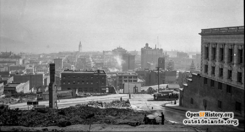
Sacramento above Powell Oct 1908

1906 Earthquake and Fire, view east from Nob Hill above Powell Street between Sacramento and Clay Streets to Ferry Building over Chinatown. Some earthquake and fire ruins exist, but much reconstruction has occurred. A cable car is seen heading south on Powell. Alaska Commercial Building (1907, Meyers and Ward, Architects), Kohl Building, Merchant's Exchange Building, Clunie Building, Sing Fat Building (1907) and Old St. Mary's Church are seen in the background right of center. Fairmont Hotel at right. In far left background, Appraisers Building, Montgomery Block, U.S. Customs House under construction. Bank of Italy Building at Montgomery and Clay beyond chimney at left. Donaldina Cameron House at Sacramento and Joice Streets left of center. See wnp14.1233, taken around same time.
Photographer Unknown (Courtesy of a Private Collector)

Sacramento above Powell Sacramento above Powell

<< back to previous page

On the Map (click marker for larger map)
DOWNLOAD a watermarked copy for use on your web site.
Copyright: Responsibility for observance of copyright protections when using or copying images rests exclusively with the user. Images are provided here under Fair Use. Questions about use? Check our Permissions Page.
Citation: Please cite this image with the following:
Western Neighborhoods Project - wnp14.4824
Use this form for any comments, corrections, or thoughts you have on this particular image.